Exploring from the Deep Sea to Deep Space

Exploring from the Deep Sea to Deep Space
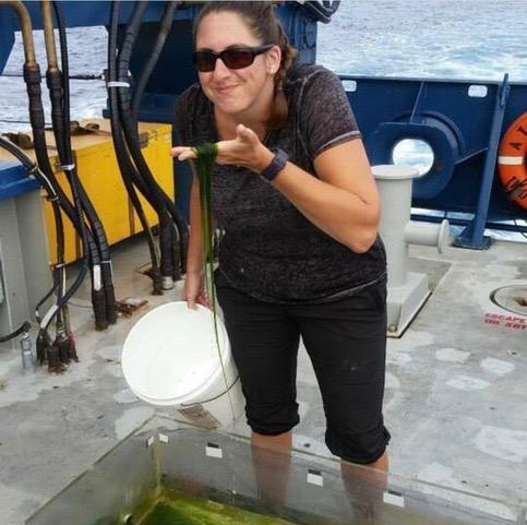
This blog was written by Shannon Cofield, PhD, Geological Oceanographer with the Bureau of Ocean Energy Management and NA157 science team member.
Who am I?
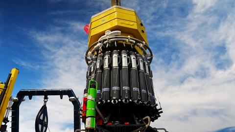
I’m a Geological Oceanographer with the Bureau of Ocean Energy Management (BOEM)- Marine Minerals Division. During this Expedition (NA157) aboard the E/V Nautilus, a multi-disciplinary team of scientists, engineers, mappers, and science communicators aim to map relatively unexplored regions of the seafloor, as well as collect oceanographic data at various depths, including temperature, salinity, nutrients, and environmental DNA (eDNA). With the seafloor at the time I write this being 4,500 meters (14,700 feet) below the ocean water surface, it’s easy to see why it’s considered an extreme environment. On land, 14,700 feet would be taller than the largest Rocky Mountain peaks in Colorado, United States.
I attended graduate school at Old Dominion University (Norfolk, Virginia), where my PhD focused on deep-sea Arctic Ocean sediments as a proxy for paleoclimate. In other words, I used the geochemistry of Arctic Ocean sediment as clues to glacial ice and sea ice movement during the glacial periods.
During my graduate studies, I also researched a different type of extreme environment. I interned with NASA’s Jet Propulsion Laboratory (NASA-JPL) on the Mars Science Laboratory Curiosity Rover Team and the Perseverance Rover Landing Site Selection Team. For both missions, I helped develop geologic maps in support of rover operations. The maps were constructed with satellite data from the Mars Reconnaissance Orbiter’s High Resolution Imaging Science Experiment (HiRISE) Camera. When I developed our maps for the Curiosity rover, the rover was already exploring the rocks and environment at Gale Crater, Mars. However, the maps for the Perseverance rover were used as part of a campaign for the Jezero Crater landing site. In fact, the rover didn’t even have a name yet and was just referred to as the “Mars2020 rover”. As luck would have it, NASA selected our location as the final landing site. It was surreal to watch a nearly livestream video of the rover landing at the location I spent years mapping and analyzing.
How does a deep sea geological oceanographer also research Mars?
Early in my studies, I learned the value of interdisciplinary opportunities. By nature, oceanography systems are complex and require interdisciplinary knowledge. We need to understand the principles and interactions between physics, chemistry, biology, geology, and atmospheric sciences. In addition to oceanography, I was trained as a traditional terrestrial geologist, specifically a sedimentologist.
Believe it or not, most planetary scientists are not explicitly trained as planetary scientists. They apply their own discipline to other planets, moons, suns, and related engineering. I applied my knowledge of Earth’s sedimentology and geologic mapping to another rocky planet, Mars. Biologists applying their expertise to other planets, or even protection of our own planet from potential biological contaminants on returning spacecraft, are known as astrobiologists and planetary protection. Of course, there are differences between Earth and Mars geology, but uncovering those differences is part of the fun!
I was extremely grateful to have a PhD Advisor, Dr. Dennis Darby, who supported my research with NASA-JPL. Likewise, in my current position with BOEM, I am also encouraged to follow my passions and brainstorm research projects from the deep sea to coastal regions.
How is exploring the deep sea similar to exploring deep space?
The deep sea and Mars have more in common than most people might assume. Both environments are extremely difficult to visit and research--especially by humans. We have satellites mapping Mars, while research vessels, such as the E/V Nautilus have geophysical survey capabilities to map the deep seafloor. On Mars, rovers explore the surface by taking images, atmospheric measurements, and analyzing rocks. In the deep sea, Robotic Operating Vehicles (ROVs), such as Hercules, regularly visit the deep sea to analyze the environment, sample rocks and deep-sea fauna, and document the dives through videos and images.
Both extreme environments are within our “robotic reach” but lack the full accessibility for humans to regularly visit for extensive research...for now. Scientists and engineers rely on these distant mapping techniques and robotic explorers to continue learning about our deep sea and solar system.
How does extreme environment exploration help humans on Earth?
From a science point-of-view, learning more about our solar system and our own planet will always benefit humans’ understanding of the natural world. We know so little about the deep sea, but it serves a vital role in our planet’s climate through the carbon cycle (carbon storage), maintaining heat (water’s heat capacity and albedo), providing a unique habitat for deep-sea fauna, and many more systems.
Extreme environments also provide opportunities for technological advances that may directly impact everyone. Biopharmaceutical companies are researching deep-sea fauna that may provide revolutionary medical treatments. Engineering instruments to withstand extreme pressures of the deep sea pushes the limits of our known engineering and material capabilities, thereby advancing technology capabilities. An increased focus on autonomous instruments will not only make deep-sea research safer but more accessible and efficient for researchers around the world.
Without researching the “extremes,” science and technology wouldn’t be pushed to their limits. For people, personal growth happens when we step outside of our comfort zones, and it’s often the same for technological advancement.
What should I study if I want to be an extreme environment explorer?
As I mentioned, interdisciplinary studies are an excellent way to expand potential opportunities. In my career, I have simultaneously been an oceanographer, Arctic Ocean sedimentologist, geologic mapper, paleoclimatologist, and Mars geologist. For high school and college students, I recommend taking some courses that complement your field, especially if they are outside your comfort zone. As an oceanographer, you might consider engineering or geography/geographic information systems courses. The ability of engineers and scientists to efficiently communicate is one of the most underrated skills. I always encourage students to learn a couple of computer languages and brush up on their coding skills. You don’t need to be an expert in any specific field, but having generalized versatility could provide opportunities you’ve never considered.
Where can I learn more?
Have I convinced you to pursue a career in exploring extreme environments? Do you have some burning questions related to the deep sea or Mars geology? Are you looking for more educational resources? If so, please feel free to reach out to me here:
Twitter @MarsRoverMapper
Instagram @geo_shanz
Hawaiʻi Mapping
This ten-day expedition will start and end in Honolulu and utilize the deep-water mapping capabilities of E/V Nautilus to survey previously unmapped seafloor in the U.S. EEZ south of the Main Hawaiian Islands.