Mapping Pacific Seamounts to the Hawaiian Islands

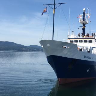
As E/V Nautilus’ operations move for the first time to areas around Hawaiian Islands, this expedition will conduct mapping while in transit over August 6-19, 2018, from Sidney, British Columbia to Hilo, Hawai'i. The transit route has been planned to fill in gaps in seabed mapping coverage across the Pacific, plus targeted mapping of a number of seamounts in the vicinity of the Murray Fracture zone. Nautilus will also do some initial mapping of recent lava flow from Kīlauea Volcano. For this expedition, Dr. Larry Mayer, Center for Coastal and Ocean Mapping at the University of New Hampshire will be Lead Scientist, with Lindsay Gee, Science & Mapping Coordinator for Ocean Exploration Trust serving as Expedition Leader. Research funding support for this expedition comes from NOAA’s Office of Ocean Exploration and Research and Ocean Exploration Trust.
Systematic mapping of the seafloor by echosounder commenced nearly a century ago, however, more than 80% of the world’s seafloor is still not mapped, and the eastern Pacific Ocean is no exception. E/V Nautilus is equipped with a Kongsberg EM302 multibeam sonar and Knudsen K3260 sub-bottom echosounder to collect bathymetric, surface sediment characteristic, subsurface geology and water column data.
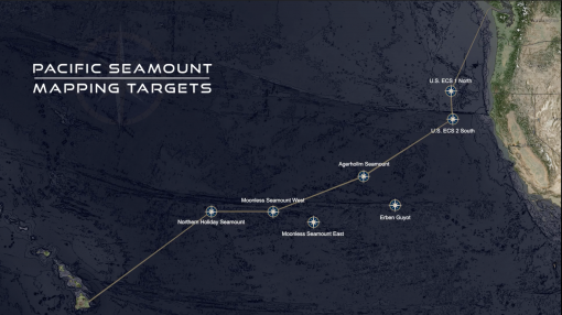
The route will commence with passage to cross the Mendocino Fracture zone, to complete a line of mapping in support of the U.S. Extended Continental Shelf Project and further illuminate the complex geologic processes in this region. Another mapping target includes a series of linear seamounts to the south of the Murray Fracture Zone, from the Moonless Mountains in the east to the Maher Seamount over 500 nautical miles to the west. Mapping from Nautilus will support the analysis of the geological structure and processes of these aligned seamounts, and their relationship to the adjacent fracture zone. It is planned to map a broad swath along the seamounts and select a number to map in detail based on time available, and depth and features derived from the initial mapping. There is also a particular management interest in surveying shallow North Pacific seamounts that may be potential targets for deep-sea bottom fishing, and also host vulnerable marine ecosystems, such as deep-sea coral and sponge habitats.
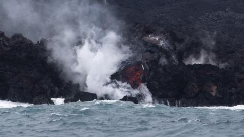
As Nautilus approaches the Hawaiian Islands near the end of this mapping transit, the team will map near the site of recent lava eruptions at Kīlauea Volcano. Eruptions of lava from Kīlauea’s Lower East Rift Zone began in early May, and over 20 fissures have poured out more than 9 million cubic-meters of lava. What happens under the ocean surface as new lava is deposited is not well understood, and the goal of this project is to acoustically map the coastal region around the ocean entry using a multibeam sonar to look at the shape and reflectivity of the seafloor in the area of lava delta formation. This timely mapping work will continue over several 2018 Nautilus expeditions, and is collaboratively funded by the National Science Foundation Ocean Sciences Division and NOAA Ocean Exploration Research Program and supported by the Ocean Exploration Trust.
Pacific Seamount Mapping
This expedition is primarily a transit mapping leg from Sidney, British Columbia to Hilo, Hawai'i as the E/V Nautilus’ operations move for the first time to areas around Hawai'i. The transit route has been planned to fill in gaps in seabed mapping coverage across the Pacific, plus targeted mapping of a number of seamounts in the vicinity of the Murray Fracture zone.