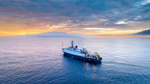
Continuing Our Exploration of Unknown Seamounts Near Kingman Reef and Palmyra Atoll

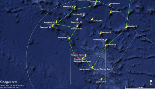
The deep-water areas around Kingman Reef and Palmyra Atoll are within one of the largest marine protected areas in the world, the Pacific Remote Islands Marine National Monument (PRIMNM). Despite a growing number of expeditions to explore deep-sea environments of the PRIMNM, the region is truly massive (495,189 square miles or 1,282,534 square kilometers) and many areas remain unexplored. Our 2022 expedition into the remote waters of Kingman Reef and Palmyra Atoll will continue to advance our understanding of seafloor habitats in the US Exclusive Economic Zone both inside and outside the protection of PRIMNM.
PRIMNM was established in 2009 and later expanded in 2014, encompasses seven islands and atolls as well as numerous seamounts, guyots, banks, and ridges across its five units. PRIMNM’s Kingman Reef and Palmyra Atoll Unit is restricted to a rectangular zone around the reef and atoll, but also contains numerous seamounts, ridges, and canyons. Most exploration activities to date have focused on features within the monument boundaries. Seamounts and guyots external to PRIMNM, but within the US EEZ, remain relatively poorly mapped and explored and will be prioritized during this expedition.
The Monument protects near shore and coral reef ecosystems and is critical for its connecting of shallow and deep water systems. The monument and the national wildlife refuges within it protect entire ecosystems – from coral reefs to deep seamounts, abyssal plain, and volcanic features. This is vital for the species that depend on the ocean - from marine mammals to green sea turtles to seabirds. Here, all ecosystems are connected; birds nourish shallow water corals which in turn feed fish communities that travel to the deeper sea; surface productivity feeds and fuels deeper reef ecology.
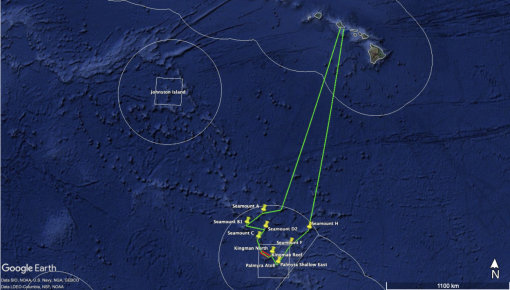
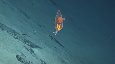
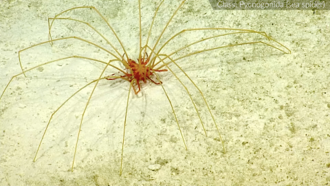
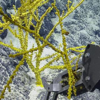
In this area almost 1,000 miles away from Honolulu, we hope to survey over 15 seamounts in over 20 different ROV dives. Most of these seamounts have never been explored and we hope to dive as deep as 4,000 m in some areas, targeting a diversity of geomorphological features including steep slopes, ridge crests, valleys and more. As a southeastern boundary of the Pacific Prime Crust Zone, seamounts in this area are of interest to the scientific community for collection of mineral crusts, as well as the characterization of biological communities that reside attached to these substrates. Finally, additional efforts to identify constituent species of deep-water coral and sponge communities will be made in order to better understand the geographic and bathymetric extent of sensitive, long-lived habitat-forming organisms present in this region.
Nautilus first explored this region of the Central Pacific during a 2019 expedition, On that expedition the team spent 76 hours on the ocean’s floor and covered depth ranges of 1,400 to 3,200 m, producing high-resolution seafloor maps and attempting to characterize vulnerable or sensitive habitats. We will continue this observation and sampling and assess targeted biology through voucher specimen collection with the hope of identifying new species and enhancing our knowledge of species’ biogeographic range.
Building on recent efforts to improve knowledge of deep-water geology and ecosystems of the Line Islands region, this expedition will aim to target more seafloor features (e.g. seamounts, guyots, ridges, and canyons) and depth ranges that have not yet been previously characterized. Rock sampling across unexplored features in this region will provide additional constraints on the complex volcanic and tectonic history of the northern Line Islands.
This expedition is funded by NOAA Ocean Exploration via the Ocean Exploration Cooperative Institute. Data gathered from this journey will support the National Strategy for Ocean Mapping, Exploring, and Characterizing the United States Exclusive Economic Zone by conducting high-resolution, in situ exploration and characterization in areas that meet the goals of the Ocean Exploration Cooperative Institute. Video analyses done post-expedition will be done by the Deep Sea Coral Research and Technology Program. OET’s work continues to contribute to Nippon Foundation-GEBCO Seabed 2030, an ambitious project to create a free, definitive, and publicly available map of the world's ocean floor by the year 2030.
Kingman Reef & Palmyra Atoll
The deep-water areas around Kingman Reef and Palmyra Atoll are within one of the largest marine protected areas in the world, the Pacific Remote Islands Marine National Monument (PRIMNM). Despite a growing number of expeditions to explore deep-sea environments of the PRIMNM, including a 2019 Nautilus expedition, many areas remain unexplored.