Laying the Framework: Supporting #ONCabyss in Deep-sea Monitoring and Innovation

For 28 days, E/V Nautilus will provide support to Ocean Networks Canada’s (ONC) offshore observatory located off the west coast of British Columbia, Canada, within the traditional and modern territories of the Nuu-chah-nulth (Nootka) and Coast Salish First Nations. This deep-sea network consists of an 800-kilometer loop of fiber optic cable that supplies continuous power and Internet connectivity to over 1000 instruments and sensors, enabling long-term observations not afforded by traditional ship-based ocean exploration. The University of Victoria’s Ocean Networks Canada monitors the west and east coasts of Canada and the Arctic to continuously deliver real-time free data for scientific research and informed decision-making about our rapidly changing ocean.
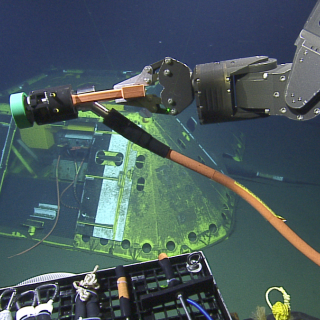
Marking the sixth year of the partnership between Ocean Networks Canada and Ocean Exploration Trust, in addition to deploying and maintaining over 100 observatory instruments, E/V Nautilus will conduct seafloor mapping surveys, ROV surveys, and document geology and biology found at observatory installations. Observatory sites we will visit during this expedition include tectonically active subduction zones at Barkley Canyon and Clayoquot Slope, the abyssal plain at Cascadia Basin, and Endeavour hydrothermal vent field. Each observatory node along the cable is instrumented with a diverse suite of sensors that enable researchers to study interactions among geological, chemical, physical, and biological processes that drive the dynamic earth-ocean system over a broad spectrum of oceanic environments. This year marks our longest expedition with ONC and E/V Nautilus will also be working alongside the cable-laying ship Cable Innovator to replace older existing cables.
Barkley Canyon
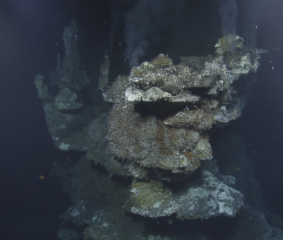
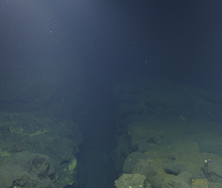
Barkley Canyon extends from the continental shelf edge at 400 meters and down the continental slope to a depth of 985 meters. Located at the leading edge of the Cascadia subduction zone, at this site sediments pile along the continental slope as they are scraped off the subducting or descending tectonic plate. This is also a location where pressure, temperature, gas saturation, and local biological and chemical conditions are just right for exposed gas hydrates to be stable on the seafloor.
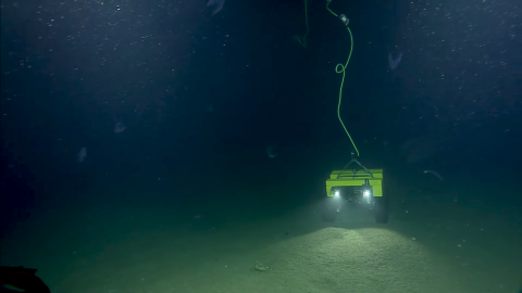
Barkley Canyon has the widest array of instruments of the observatory network, spread over the highest number of instrument platforms on one node, generating data used by a diverse set of researchers. It supports the world's first Internet operated deep-sea crawler, Wally, controlled remotely primarily by a team of scientists in Germany. While in Barkley Canyon, we will also deploy an autonomous mooring, as well as recover, maintain, and swap some instruments at various sites and collect chemical and water samples.
Clayoquot Slope
The name Clayoquot (pronounced “Clah-quot”) is an anglicized version of Tla-o-qui-aht, the largest nation in the Nuu-chah-nulth (Nootka) First Nations. The Clayoquot Slope site lies about 1250 meters below sea level and approximately 20 kilometers landward of the toe of the Cascadia subduction zone. The Cascadia subduction zone is the area where the Juan de Fuca plate is subducting beneath the North American plate. Here, a thick layer of sediment is deposited on the eastern flank of the Juan de Fuca Ridge, scraped off and accreted as the tectonic plates converge. As sediments thicken and compact from accretion, waters are expelled from the sediment, and gases — primarily biogenic methane — contribute to the formation of gas hydrates in the upper few hundred meters of the sediment. At this site, a cold vent, known as Bullseye Vent, has formed along with significant concentrations of gas hydrates.
As part of our work at Clayoquot Slope, we will continue to perform deployments, recoveries, and maintenance of various instruments including a hydrophone and rotary sonar. Our team will also conduct biological and geological surveys and sampling for routine habitat characterization.
Endeavour Vent Field
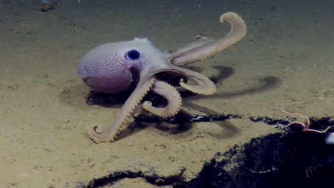
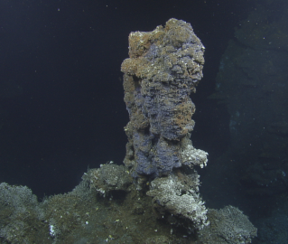
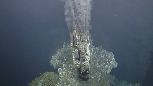
One of the most stunning regions of the ONC network is the Endeavour Vent Field, a complex hydrothermal system that marks one of the most hostile environments on Earth. Located in this seemingly uninhabitable seascape are at least a dozen species found nowhere else in the world. In 2003, it was classified as a Marine Protected Area and became the first protected marine area in Canada — and the first hydrothermal vent ecosystem protected in the world!
At a depth down to 2400 meters, Endeavour is a northern segment of the Juan de Fuca Ridge mid-ocean ridge, a medium-rate spreading center of about 6 centimeters each year between the Pacific and the Juan de Fuca tectonic plates.
In our sixth year of working with ONC, we will continue to monitor instruments like the three Benthic Resistivity Sensors located in this region. We will also deploy a 6-kilometer cable in cooperation with the cable-laying ship Cable Innovator, recover three and deploy four 300-meter long instrument moorings, as well as conduct biological and geological surveys and sampling for routine habitat characterization. Additionally, the hydrothermal vent plume will be sampled directly by ROV Hercules and compared to plume samples collected by a nearby sediment trap to understand the chemical evolution of the minerals injected into the ocean.
Cascadia Basin
The Cascadia Basin is the heavily sedimented part of the Juan de Fuca Plate that extends from the base of the continental margin to the west where the sediments lap onto the Juan de Fuca Ridge flank. A few isolated outcropping seamounts that pierce through more than 200 meters of impermeable sediments, are conduits that allow hydrologic exchange between the open ocean and the upper oceanic crust — the largest aquifer of the planet.
The Cascadia Basin site is placed in the vicinity of several circulation obviation retrofit kit (CORK) borehole observatories, which are designed to study the hydrology, geochemistry and microbiology of the upper oceanic crust, as well as earthquakes on the plate boundaries. The seafloor pressure measurements of the CORK borehole observatories serve as the center of a “tsunami-meter,” a network of several high precision, rapid sampling bottom pressure recorders (BPRs) that allow precise determination of deep water tsunami amplitude, direction of propagation, and speed. While here, we will also assist in the recovery and swapping out of a 2015 seismometer first earthquake early warning sensor, as well as deploy new cable in cooperation with the vessel Cable Innovator.
Ocean Networks Canada
For 28 days, E/V Nautilus will provide support to Ocean Networks Canada’s (ONC) NEPTUNE observatory located off the west coast of British Columbia, Canada, within the traditional and modern territories of the Nuu-chah-nulth and Coast Salish peoples.