Mapping the Revillagigedo Archipelago

Successfully completing almost three weeks of seafloor mapping in the Eastern Pacific from the Olympic Peninsula to Southern California, E/V Nautilus continues south along the West Coast of North America during this next expedition.
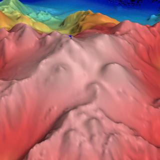
With only about 13% of our world’s oceans mapped at high-resolution, the Nautilus Exploration Program works with research partners to identify priority regions for seafloor mapping. Continuing this important groundwork from October 3-17, 2017, the Mapping the Revillagigedo Archipelago expedition will create base maps for a Nautilus expedition to explore the archipelago with ROVs Hercules and Argus in November 2017. Expedition Leader Dr. Nicole Raineault and Lead Scientist Ashore Dr. Steven Carey of the University of Rhode Island will be guiding the Nautilus team of mappers, navigators, engineers, and scientists in identifying target regions.
Laying Base Maps for Exploration
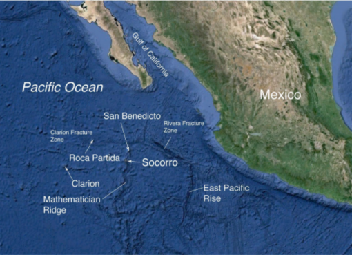
This expedition will develop base maps for the November Nautilus exploration of the Revillagigedo Archipelago--a region known as “Mexico’s Galapagos Islands” thanks to stunning biodiversity and a number of endemic species that evolved in relative isolation.
Three areas in the Revillagigedo Archipelago region have been identified to target for multibeam mapping around Socorro, San Benedicto, and Roca Partida Island as areas of interest due to recent underwater volcanic eruptions. The largest and highest priority area encompasses the island of Socorro and extends southwards along the Mathematician Ridge. The second area encompasses the island of San Benedicto and its submarine slopes down to depth of >2500 m. The third area encompasses the very small island of Roca Partida and extends down its submarine slopes to depths of >2500 m.
Near Socorro Island, possible vent sites have been identified near the site of a submarine lava balloon eruption that occurred in 1993. Like this geological phenomenon’s name suggests, lava balloons are hollow pieces of cooled lava “burped” from the seafloor that rise to the surface during certain types of underwater volcanic eruptions. As their exterior shell can be porous and absorb water once at the surface, these lava balloons don’t stick around long--humans have only documented them at the surface a handful of times!
The Nautilus team will also multibeam map areas around the Revillagigedo Archipelago and international waters where there are two possible seamounts that have been identified in previous surveys of the region. As is standard for our mapping operations, we will utilize the EM302 multibeam sonar echosounder and Knudsen sub-bottom profiler mounted on the hull of Nautilus for these surveys, as well as a retrievable underway CTD (conductivity, temperature, depth sensor) to adjust collected data.
Learn more about the mapping technology aboard E/V Nautilus.
Mapping Revillagigedo Archipelago
Moving south along the Baja California Peninsula, Nautilus will continue multibeam mapping operations in three areas to facilitate later explorations in the Revillagigedo Archipelago. The largest and highest priority area encompasses the island of Socorro and extends southwards along the Mathematician Ridge. The second and third areas encompass the islands of San Benedicto and Roca Partida, extending down their submarine slopes.